LRNSC CLUB WALK - SURREY HILLS - Sunday 19 May 2024
NB The date has now changed to Sunday 19 May from Saturday 11 May due to junction closures on the M25 which could affect journeys to the walk.
About the walk
A moderately demanding day walk for Club members of around 17km through the scenic Surrey Hills National Landscape area starting from Dorking. The walk climbs up through ancient woodland to Leith Hill, the 2nd highest point in SE England [294m] with extensive views to the south.
Leith Hill is within an Area of Outstanding Natural Beauty (AONB) and is also designated as a Site of Special Scientific Interest (SSSI).
There are refreshment opportunities at the nearby hamlet of Coldharbour.
There is reasonably priced accommodation nearby for those wishing to stay overnight either Friday or Saturday nights.
Starting point
10.00am meet for 10.30am start, Milton Heath car park (free), just off Westcott Road (A25), around 1km west of Dorking town centre and 2.5km west of Dorking main station.
The 1st parking area by the road has space for 10 cars, then there is a much larger main car park further down on the left. Alternatives can be found if this is full, but unlikely to be an issue, since the main Surrey hills car parks are elsewhere.
Postcode RH4 3JU, Ordnance Survey XY Coordinates 515500, 148900, Grid Reference TQ 1550 4890.
The leader will navigate but the handiest map of the area is the A-Z “Surrey Hills Adventure Atlas” booklet in 1:25000. OS Explorer 146 also covers the area. 1:50000 maps are insufficiently detailed to be of use.
Route
- South along footpaths and bridleways past Osier plantation and between two small lakes, then across open fields to cross Longmore Lane and gain height to Squires Farm.
- Via extensive ancient woodland of the Surrey hills proper, which has been continuously wooded since at least 1600, with many old oak, yew, beech and other varieties of trees.
- Climb steeper ground up to an old established byway called Wolvens Lane to the hamlet of Coldharbour, which has a pub and small shop selling limited takeaway food.
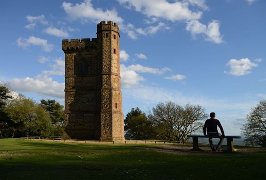
- 25 minute climb to the summit of Leith Hill with its distinctive tower (inside currently closed), with plenty of seating and places to take in the views. A packed lunch could be eaten here and the summit area explored.
- Total distance from start point, 8.3km, total 270m of height gain – approx 2 ¼ hours including stops en route.
- Return will be via a variation on the above, potentially including the pub at Coldharbour if there is demand.
Total distance approx. 17km, or around 5 ½ hours including lunch & other stops, i.e. finish time back at the car park around 4.00pm.
- For flexibility packed lunches are advised, as the pub’s eating capacity is not large.
Travel by public transport
Direct trains to Dorking Station run from Victoria (2 an hour, 56m) and Waterloo (1 an hour, 50m) see National Rail journey planner.
Car pickups to/from the station can be arranged if required.
Overnight stays/dinner
The day is structured so that London/SE based members can make it a day trip, but those travelling further could stay either night at Dorking Travelodge (2.5km east of the walk start and 1km south of Dorking station).
Other options in the area include Leatherhead Travelodge, the White Horse and Burford Bridge hotels in Dorking and some B&B’s. Pickups could be arranged for those staying locally without a car, plus there are plenty of local taxi firms. If there is sufficient demand we could take refreshments or an early dinner at a local venue after the walk.
Equipment
Footpaths in the Surrey hills are muddy most of the year, with the exception of the driest summer periods – and waterlogged lower sections before we enter the higher ground (where it is usually fairly dry but still muddy) are to be expected.
Hiking boots are essential - shoes or trainers will not suffice. Gaiters a good idea if the recent weather has been damp or you want to keep mud off your trousers.
Walking poles very useful, average gradients are gentle, but some short sections are steeper.
What to do next
Please register your interest by emailing the organiser Greg Clack before 9 May.
If you’re not already a Club member please join before the walk.

